|
CHARACTERISTICS AND VARIATIONS
Characteristics
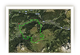
The sister of the Sellaronda is more demanding physically and goes anti-clockwise round the imposing Sella mountain range. This route is very different from the other direction and offers fascinatingly different impressions of an assumed identical tour. Three (instead of five) cable cars reduce the metres you would have to struggle up on this tour. The remaining altitude difference of just under 1,300m would not present any problems for a well-trained hobby biker. Only a few steep sections below the stony town are reserved for the aces. The same applies for this direction too, namely, it is not possible to have more descents in a day, nor a more beautiful panorama!
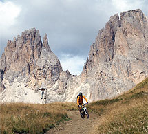
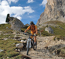
Only the first kilometres rising gently to Ciaslat are ideal for warming-up. The short, but ingenious trail leading to Monte Pana sets the tone for what this tour has to offer. A short ascent to Monte Pana, then the lift takes the bikers to the foot of the Langkofel. The steepest section of the tour is at the same time one of the most beautiful. Immediately below the mighty Langkofel the route rises extremely steeply in the direction of the Rifugio (mountain cabin) Comici. It is still too early for proper refreshments, even though you can eat very well here. But maybe you can drink something, soak up the panorama and move on. The path leading on to the stony town changes into a fantastic trail. A few especially steep sections and hair-pin bends here force most bikers to get off and push their bikes for a short distance.
You can roll along relaxed through the middle of the stony town downhill to the car park at the cable car to the Langkofelscharte and enjoy the stony witnesses of a rockfall that peeled away from the Langkofel several centuries ago.
Shortly afterwards the scenically impressive descent from Rifugio Valentini leading to Lupo Bianco begins. The Stella massif opposite is magnificent. The Sas Pordoi towers up steeply into the sky. The descent becomes steeper, you enter woodland that only thins out shortly before Lupo Bianco. Then there is a short, more demanding trail section immediately below Lupo Bianco.
Once you arrive in Canazei the cable car to Pecol kindly takes over the next good 900m of altitude difference. From the mountain station you have a wonderful view of the Fedaia reservoir and the Marmolada. Stop off and have something to eat at the Belvedere, slightly off route, and enjoy the panorama (at waymarker 52 continue straight ahead). There is a short descent to the mountain pass road – here by the way a downhill section branches off – and a short, nice ascent away from the main road to the Pordoi mountain pass.
It is best to escape the hustle and bustle up here and start immediately the stunning descent to Arabba, that begins only a few metres below the summit. A single trail meanders through meadows, then follows a section of ski piste to branch off again into a wonderful trail. The last of the descent to Arabba proves that ski pistes can also look beautiful in summer.
You roll along the road for a good two kilometres before reaching Renac, where the most remote section of the tour begins: the ascent via Cherz to the La Marmotta. The village of Cherz gives the impression of a place where time has stood still. It is wonderfully peaceful on the Malga Cherz mountain pastures. Very appropriately this ascent of a total of 450m of difference in altitude ends at the mountain cabin La Marmotta (the marmot).
The fast descent on the gravel road in the direction of Corvara is spiced up by a dream trail below the Capanna Nera. The last easy ascent of the tour begins in Corvara and goes as far as Colfosco. The cable car takes you on the remaining metres of altitude difference to the Clark mountain cabin above the Gardena Joch (ridge).
Soak up once more the magnificent display of rocks at the Gardena Joch before the last long descent to Wolkenstein begins. In the upper part trails and woodland paths alternate. Then there follows an extremely steep descent on gravel to Plan. Take care ! Your brakes can get very hot here. It is therefore better to stop every now and again to let them cool down.
The last metres back to Wolkenstein, where you arrive full of unforgettable impressions of a very unusual tour, are on the former railway line.
| |
 |
| |
Variations
1. Alternative descent from the Gardena Joch via Plan de Gralba and the ski piste: at the hairpin bend at waymarker 103 turn sharp left and follow the mountain pass road downhill. After 1,260m turn sharp right and after 540m branch off left to Plan de Gralba. Now follow the signposts to Plan de Gralba. After 3km you join the descent from Sellajoch near to the valley station of a T-bar lift. Continue to the valley station of Piz Sella and then branch off left to Plan. After 100m bear right on the ski piste to Wolkenstein. After 1.3km, you reach the main road where you take a sharp right turn. After 60m you join the tour described here at the Casa Alpina at waymarker 113 and continue taking a sharp left turn.
2. Hammer tour via Duron valley: do not take the lift at the valley station in Monte Pana, but continue straight ahead. This corresponds to waymarker 81 of the tour into Duron valley. Take this tour now in the opposite direction via Mahlknechtjoch into Duron valley and continue via Campitello to Canazei (waymarkers 81-38). At the church in Canazei, you again join the tour described here (waymarker 47) and follow it bearing right into the one-way street (+12km, +540m altitude difference). |
| |
|
| |
TOUR INFORMATION
Tour information |
|
% of distance |
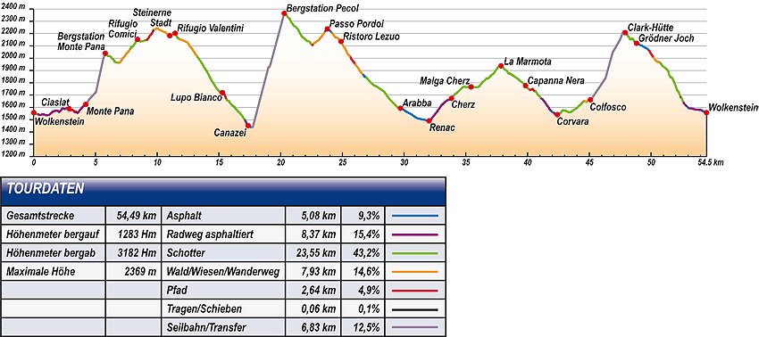
Total distance |
54,49 km |
100 % |
Height variation uphill |
1283 Hm |
|
Height variation downhill |
3182 Hm |
|
Maximum altitude |
2369 m |
|
Tarmac |
5,08 km |
| 9,3 % |
 |
|
Tarmac cycle path |
8,37km |
15,4 %
|
 |
|
Gravel |
23,55 km |
| 43,2 % |
 |
|
Hiking trail |
7,93 km |
14,6 %
|
 |
|
Single track |
2,64 km |
4,6 %
|
 |
|
Carrying / pushing |
0,06 km |
0,1 %
|
 |
|
Cable car / transfer |
6,83 km |
12,5 %
|
 |
|
|
| |
|
|
Riding times |
Riding time without pauses |
Riding time at 10 km/h |
5 hrs 27 min |
Riding time at 12 km/h |
4 hrs 32 min |
Riding time at 14 km/h |
3 hrs 54 min |
Riding time at 16 km/h |
3 hrs 24 min |
Riding time at 18 km/h |
3 hrs 02 min |
Riding time at 20 km/h |
2 hrs 43 min |
| |
|
| |
|
| |
|
| |
|
| |
|
|
|
| |
|
Physical condition |
|
|
Overall condition |
4,0 |
|
Total height variation |
4,0 |
|
Total distance |
4,0 |
|
Maximum altitude |
4,0 |
|
|
|
Riding technique |
|
|
Overall riding technique |
3,4 |
|
Surface |
2,9 |
|
Average climb gradient Ø |
4,0 |
|
Average descent gradient Ø |
4,0 |
|
|
|
| |
|
Tour evaluation |
|
|
Overall difficulty |
3,7 |
|
Climb difficulty |
3,6 |
|
Descent difficulty |
3,8 |
|
|
|
Emotional experience |
|
|
Panorama |
5,0 |
|
Riding fun |
4,0 |
|
| |
|
|
|
|
| |
|
GETTING THERE AND STARTING POINT
Getting there
Take Brenner motorway A22, coming from the north via Innsbruck-Brenner, or from the south via Verona-Bozen.
The best motorway exit is Klausen/Gröden. From there in about 20 minutes you can reach St Ulrich and a few kilometres further on St. Christina and Wolkenstein on a clearly signposted mountain road.
Starting point
The tourism association is located on the left about 500m after you enter the village of Wolkenstein.
Parking is available at the the beginning of the village centre of Wolkenstein. Turn left before Nives Platz and then immediately left again into the Nives car park.
The tour begins at the tourism association Wolkenstein.
|
| |
ROADBOOK
No |
km |
Next |
Hm |
Sym |
Location |
Direction |
Route |
Time 22 km/h |
Time 10 km/h |
1 |
0,00 |
0,05 |
1557 |
|
Tourist information office in Wolkenstein/Selva |
Straight on downhill |
|
00:00 |
00:00 |
2 |
0,05 |
0,05 |
1554 |
|
Café Mozart |
Sharp left onto permanent hiking trail |
|
00:00 |
00:00 |
3 |
0,10 |
0,06 |
1550 |
|
Casa Elisabetha |
Sharp right downhill |
|
00:00 |
00:00 |
4 |
0,17 |
0,20 |
1548 |
|
End of tarmac |
Straight on |
|
00:00 |
00:00 |
5 |
0,37 |
0,08 |
1543 |
|
Fire station |
Straight on |
|
00:01 |
00:02 |
6 |
0,45 |
0,43 |
1540 |
|
House of Culture |
Bear left |
|
00:01 |
00:02 |
7 |
0,88 |
0,18 |
1541 |
|
Junction at signpost 30 |
Straight on |
|
00:02 |
00:05 |
8 |
1,06 |
0,51 |
1535 |
|
Junction with hiking trail 22A |
Straight on following road |
|
00:02 |
00:06 |
9 |
1,57 |
0,25 |
1567 |
|
Transformer, bus stop La Selva |
Bear right to Monte Pana |
|
00:04 |
00:09 |
10 |
1,81 |
0,89 |
1572 |
|
Junction to Fischburg |
Straight on to Monte Pana |
|
00:04 |
00:10 |
11 |
2,71 |
0,04 |
1592 |
|
End of tarmac |
Straight on |
|
00:07 |
00:16 |
12 |
2,75 |
0,12 |
1587 |
|
Junction |
Straight on |
|
00:07 |
00:16 |
13 |
2,87 |
0,09 |
1590 |
|
Ciaslat (towards Sellajoch/Passo Sella) |
Straight on |
|
00:07 |
00:17 |
14 |
2,96 |
0,50 |
1581 |
|
End of gravel path |
Straight on |
|
00:08 |
00:17 |
15 |
3,46 |
0,08 |
1562 |
|
Beginning of tarmac |
Straight on |
|
00:09 |
00:20 |
16 |
3,54 |
0,58 |
1555 |
|
App. Prensanueva |
Bear left to Monte Pana |
|
00:09 |
00:21 |
17 |
4,12 |
0,09 |
1625 |
|
Junction to S. Cristina, Selva/Wolkenstein |
Bear left following road |
|
00:11 |
00:24 |
18 |
4,21 |
1,58 |
1624 |
|
Crossing with bottom of Monte Pana lift |
Take lift up |
|
00:11 |
00:25 |
19 |
5,79 |
0,81 |
2040 |
|
Top of Monte Pana lift |
Bear left to Comici, Sellajoch/Passo Sella |
|
00:15 |
00:34 |
20 |
6,60 |
0,30 |
1968 |
|
Junction |
Bear right to Comici, Sellajoch/Passo Sella |
|
00:18 |
00:39 |
21 |
6,90 |
0,06 |
1963 |
|
Junction to Wolkenstein/Selva |
Straight on to Comici, Sellajoch/Passo Sella |
|
00:18 |
00:41 |
22 |
6,96 |
0,34 |
1965 |
|
Junction 22c (gate) |
Straight on |
|
00:18 |
00:41 |
23 |
7,30 |
0,52 |
2008 |
|
Junction with hiking trail (snow gun connector) |
Bear left |
|
00:19 |
00:43 |
24 |
7,82 |
0,47 |
2077 |
|
Intersection with gravel road |
Right uphill |
|
00:21 |
00:46 |
25 |
8,29 |
0,11 |
2137 |
|
Junction to Ciampinoi |
Bear left to Sellajoch/Passo Sella |
|
00:22 |
00:49 |
26 |
8,40 |
0,02 |
2153 |
|
Comici Hut |
Strait on to Passo Sella, City of Stone |
|
00:22 |
00:50 |
27 |
8,42 |
0,74 |
2152 |
|
Junction |
Straight on |
|
00:22 |
00:50 |
28 |
9,16 |
0,53 |
2148 |
|
Junction |
Bear right to City of Stone |
|
00:24 |
00:54 |
29 |
9,69 |
0,06 |
2226 |
|
Beginning of pushing section |
Straight on |
|
00:26 |
00:58 |
30 |
9,76 |
1,27 |
2235 |
|
End of pushing section |
Straight on |
|
00:26 |
00:58 |
31 |
11,02 |
0,06 |
2183 |
|
Bottom of Langkofelscharte lift, end of City of Stone |
Straight on |
|
00:30 |
01:06 |
32 |
11,08 |
0,11 |
2181 |
|
Car park of Langkofelscharte lift |
Sharp right uphill |
|
00:30 |
01:06 |
33 |
11,19 |
0,16 |
2190 |
|
Junction near chapel |
Straight on |
|
00:30 |
01:07 |
34 |
11,35 |
0,10 |
2212 |
|
Crossroads (to Salei Hut) |
Straight on Valentini Hut |
|
00:30 |
01:08 |
35 |
11,46 |
0,35 |
2203 |
|
Valentini Hut |
Left downhill |
|
00:31 |
01:08 |
36 |
11,81 |
1,46 |
2154 |
|
End of gravel road |
Straight on |
|
00:32 |
01:10 |
37 |
13,27 |
0,75 |
2009 |
|
Val 2000 |
Right to Lupo Bianco |
|
00:36 |
01:19 |
38 |
14,02 |
0,94 |
1893 |
|
Wayside cross |
Sharp left downhill |
|
00:38 |
01:24 |
39 |
14,96 |
0,15 |
1738 |
|
Bridge over stream |
Straight on to Canazei |
|
00:40 |
01:29 |
40 |
15,11 |
0,05 |
1724 |
|
Junction |
Straight on |
|
00:41 |
01:30 |
41 |
15,15 |
0,12 |
1724 |
|
Plan de Frataces 1725 |
Bear right |
|
00:41 |
01:30 |
42 |
15,28 |
0,14 |
1720 |
|
Lupo Bianco (lake) |
Bear left Canazei 655 |
|
00:41 |
01:31 |
43 |
15,42 |
0,20 |
1713 |
|
Junction |
Straight on |
|
00:42 |
01:32 |
44 |
15,62 |
0,18 |
1662 |
|
Bend 8 |
Stay on trail |
|
00:42 |
01:33 |
45 |
15,80 |
1,33 |
1654 |
|
Intersection with gravel road |
Sharp right downhill |
|
00:43 |
01:34 |
46 |
17,13 |
0,24 |
1494 |
|
Bridge |
Bear left over bridge |
|
00:46 |
01:42 |
47 |
17,36 |
0,21 |
1452 |
|
Church of Canazei |
Cross into one-way street |
|
00:47 |
01:44 |
48 |
17,57 |
0,13 |
1440 |
|
Intersection with main road |
Left to Pecol cable car |
|
00:47 |
01:45 |
49 |
17,70 |
1,32 |
1439 |
|
Bottom of Belvedere lift |
Take cable car |
|
00:48 |
01:46 |
50 |
19,03 |
1,27 |
1926 |
|
Middle station |
Change lifts |
|
00:51 |
01:54 |
51 |
20,29 |
0,33 |
2365 |
|
Top of Pecol cable car |
Straight on |
|
00:55 |
02:01 |
52 |
20,63 |
1,97 |
2328 |
|
Near start of downhill section |
Bear left downhill |
|
00:56 |
02:03 |
53 |
22,59 |
0,08 |
2107 |
|
Hotel Gonzaga, bend 19 |
Sharp right Passo Pordoi |
|
01:01 |
02:15 |
54 |
22,67 |
0,02 |
2119 |
|
Benches |
Bear right |
|
01:01 |
02:16 |
55 |
22,69 |
0,94 |
2121 |
|
Reservoir |
Sharp left uphill Passo Pordoi |
|
01:01 |
02:16 |
56 |
23,63 |
0,15 |
2221 |
|
Sass Pordoi cable car |
Bear right uphill |
|
01:04 |
02:21 |
57 |
23,78 |
0,40 |
2238 |
|
|
Straight on downhill |
|
01:04 |
02:22 |
58 |
24,18 |
0,04 |
2203 |
|
Signpost “Benvenuti a Belluno” |
Sharp left Proprietà privata |
|
01:05 |
02:25 |
59 |
24,22 |
0,67 |
2197 |
|
Barn |
Right to Arabba 680 |
|
01:06 |
02:25 |
60 |
24,90 |
0,52 |
2136 |
|
Back of Ristoro Lezuo |
Left to Arabba |
|
01:07 |
02:29 |
61 |
25,41 |
0,27 |
2036 |
|
Intersection with gravel road |
Straight on |
|
01:09 |
02:32 |
62 |
25,68 |
0,38 |
2006 |
|
Inconspicuous path junction near 2 huts |
Left to Arabba |
|
01:10 |
02:34 |
63 |
26,06 |
0,65 |
1948 |
|
Start of wider path |
Straight on |
|
01:11 |
02:36 |
64 |
26,71 |
0,24 |
1863 |
|
Intersection with bend |
Straight on downhill |
|
01:12 |
02:40 |
65 |
26,95 |
2,46 |
1844 |
|
Imbiss Peter snack bar |
Sharp right onto ski piste |
|
01:13 |
02:41 |
66 |
29,41 |
0,03 |
1607 |
|
Intersection with gravel road near bottom Porto Vescovo lift |
Left downhill |
|
01:20 |
02:56 |
67 |
29,44 |
0,05 |
1602 |
|
Junction with gravel road |
Straight on downhill |
|
01:20 |
02:56 |
68 |
29,49 |
0,13 |
1599 |
|
Bridge over stream |
Cross bridge |
|
01:20 |
02:56 |
69 |
29,62 |
0,10 |
1598 |
|
Casa Cantoniva |
Bear right downhill |
|
01:20 |
02:57 |
70 |
29,71 |
0,06 |
1593 |
|
Church of Arabba |
Bear left into Zona traffico limitato |
|
01:21 |
02:58 |
71 |
29,77 |
0,07 |
1592 |
|
Ristorante Posta |
Bear right |
|
01:21 |
02:58 |
72 |
29,84 |
2,18 |
1586 |
|
Arabba roundabout |
Straight on to Belluno |
|
01:21 |
02:59 |
73 |
32,02 |
0,98 |
1491 |
|
Bar Bianco in Renac |
Bear left to Cherz |
|
01:27 |
03:12 |
74 |
33,00 |
0,84 |
1613 |
|
Junction to Masozi |
Straight on uphill |
|
01:29 |
03:17 |
75 |
33,83 |
1,59 |
1673 |
|
End of Cherz village |
Straight on uphill |
|
01:32 |
03:23 |
76 |
35,42 |
2,24 |
1767 |
|
Cherz Hut |
Straight on to Incisa Hut |
|
01:36 |
03:32 |
77 |
37,66 |
0,19 |
1928 |
|
Incisa Hut (Water source) |
Straight on |
|
01:42 |
03:45 |
78 |
37,86 |
1,12 |
1938 |
|
La Marmota |
Straight on to Capanna Nera, Corvara |
|
01:43 |
03:47 |
79 |
38,98 |
0,86 |
1849 |
|
Crossing with hiking trail 25 |
Straight on Corvara 24 |
|
01:46 |
03:53 |
80 |
39,84 |
0,23 |
1776 |
|
Near Capanna Nera |
Bear left to Corvara 24 |
|
01:48 |
03:59 |
81 |
40,07 |
0,11 |
1753 |
|
Golf course |
Right to Corvara 24 |
|
01:49 |
04:00 |
82 |
40,18 |
0,47 |
1743 |
|
Electricity mast by golf course |
Right to Corvara 24 |
|
01:49 |
04:01 |
83 |
40,65 |
0,47 |
1733 |
|
Intersection with bend |
Bear left downhill Corvara |
|
01:50 |
04:03 |
84 |
41,12 |
0,11 |
1671 |
|
Hotel Arlara |
Right |
|
01:52 |
04:06 |
85 |
41,22 |
0,45 |
1666 |
|
Sporthotel Panorama |
Sharp left downhill |
|
01:52 |
04:07 |
86 |
41,67 |
0,32 |
1607 |
|
Junction with Str. Col |
Left downhill |
|
01:53 |
04:10 |
87 |
41,99 |
0,16 |
1564 |
|
Pension La Fontana |
Right downhill |
|
01:54 |
04:11 |
88 |
42,15 |
0,28 |
1555 |
|
Corvara mountain guide office |
Left into Str. Rü Tort |
|
01:54 |
04:12 |
89 |
42,42 |
0,22 |
1541 |
|
Hotel Arkadia, near bottom of Boè lift |
Left to Colfosco |
|
01:55 |
04:14 |
90 |
42,64 |
0,81 |
1553 |
|
Junction under drag lift |
Straight on Borest trail |
|
01:56 |
04:15 |
91 |
|
0,52 |
1561 |
|
Camp site |
Bear left to Mittagstal/Val Mezdì |
|
01:58 |
04:20 |
92 |
43,98 |
0,67 |
1593 |
|
Bridge over stream |
Bear left to Grödner Joch/Passo Gardena |
|
01:59 |
04:23 |
93 |
44,65 |
0,44 |
1651 |
|
Junction (Water source) |
Right Plans Frara Colfosco |
|
02:01 |
04:27 |
94 |
45,09 |
2,67 |
1662 |
|
Bottom of Colfosco cable car |
Take cable car |
|
02:02 |
04:30 |
95 |
47,76 |
0,16 |
2219 |
|
Top station |
Straight on |
|
02:10 |
04:46 |
96 |
47,92 |
0,47 |
2208 |
|
Clark Hut |
Straight on downhill |
|
02:10 |
04:47 |
97 |
48,39 |
0,08 |
2155 |
|
Junction |
Straight on |
|
02:11 |
04:50 |
98 |
48,47 |
0,22 |
2162 |
|
Intersection with gravel road |
Bear left downhill |
|
02:12 |
04:50 |
99 |
48,69 |
0,14 |
2131 |
|
Hotel Cir |
Left downhill |
|
02:12 |
04:52 |
100 |
48,83 |
0,19 |
2121 |
|
Grödner Joch/Passo Gardena |
Sharp right downhill |
|
02:13 |
04:52 |
101 |
49,02 |
0,17 |
2115 |
|
Car park |
Straight on downhill |
|
02:13 |
04:54 |
102 |
49,19 |
0,70 |
2103 |
|
Junction to Wolkenstein/Selva 654 |
Straight on downhill |
|
02:14 |
04:55 |
103 |
49,88 |
0,35 |
2059 |
|
Crossing with hiking trail in bend |
Bear left downhill Wolkenstein/Selva |
|
02:16 |
04:59 |
104 |
50,23 |
0,52 |
2005 |
|
Intersection |
Straight on downhill |
|
02:17 |
05:01 |
105 |
50,75 |
0,55 |
1962 |
|
Junction with hiking trail 653 |
Bear right to Selva 654 |
|
02:18 |
05:04 |
106 |
51,30 |
0,07 |
1905 |
|
Junction |
Straight on to Selva 654 |
|
02:19 |
05:07 |
107 |
51,37 |
0,19 |
1903 |
|
Junction |
Straight on steeply downhill to Selva 654 |
|
02:20 |
05:08 |
108 |
51,56 |
0,86 |
1851 |
|
Junction Trail |
Straight on downhill |
|
02:20 |
05:09 |
109 |
52,41 |
0,05 |
1683 |
|
Intersection with tarmac road |
Straight on downhill |
|
02:22 |
05:14 |
110 |
52,47 |
0,19 |
1675 |
|
Bend in main road |
Straight on downhill to Selva 654 |
|
02:23 |
05:14 |
111 |
52,66 |
0,27 |
1673 |
|
Wooden bridge |
Straight on downhill |
|
02:23 |
05:15 |
112 |
52,93 |
0,14 |
1606 |
|
Hotel Plan Alpino |
Right downhill |
|
02:24 |
05:17 |
113 |
53,07 |
0,77 |
1593 |
|
Casa Alpina |
Bear right (left along sports ground) |
|
02:24 |
05:18 |
114 |
53,84 |
0,28 |
1581 |
|
Hotel La Tambra |
Bear left onto course of old railway |
|
02:26 |
05:23 |
115 |
54,12 |
0,09 |
1577 |
|
Hotel Sun Valley |
Sharp left downhill |
|
02:27 |
05:24 |
116 |
54,21 |
0,04 |
1567 |
|
Intersection with main road |
Sharp right |
|
02:27 |
05:25 |
117 |
54,25 |
0,09 |
1566 |
|
Hotel Krone |
Bear left following main road |
|
02:27 |
05:25 |
118 |
54,33 |
0,17 |
1566 |
|
Bottom of Ciampinoi lift |
Straight on |
|
02:28 |
05:25 |
119 |
54,50 |
0,00 |
1557 |
|
Tourist information office in Wolkenstein/Selva |
End of tour |
|
02:28 |
05:26 |
EXPLANATION OF EVALUATION FACTORS, SURFACE AND SLOPE
Explanation of evaluation factors
• Overall difficulty based on climb difficulty (60%) and descent difficulty (40%)
• Climb difficulty based on total distance uphill (30%), overall height variation uphill (30%), surface uphill (10%), average slope uphill (25%), highest altitude reached (5%).
• Descent difficulty consists of total distance downhill (10%), overall height variation downhill (10%), surface downhill (50%), average slope downhill (30%).
• Physical condition based on total distance (40%), with overall height variation (50%) and highest altitude reached (10%).
• Riding technique based on surface (50%), with average slope uphill (30%) and average slope downhill (20%).
• Writer’s subjective evaluation of panorama and riding fun.
Explanation of surface and slope |
|
|
|
A = Tarmac road |
|
steep uphill |
from + 15% |
R = Tarmac cycle path |
|
uphill |
up to + 14% |
S = Gravel |
|
level |
ca. +/- 4% |
W = Hiking trail |
|
downhill |
up to - 19% |
P = Path, Single Trail |
|
steep downhill |
from - 20% |
T = Carrying / pushing |
|
|
|
X = Cable car / transfer |
|
|
|
Route: the percentages indicate the average climb (+) or the average descent (-) to the next waymarker. |
DOWNLOADS
| |
 |
 |
 |
 |
CHARACTERISTICS |
ALTITUDE PROFILE |
ROADBOOK |
MAP |
|
| |
It is recommended to discover the "Anti-clockwise tour of the Sellaronda" accompanied by an official national mountain bike guide (www.sellaronda-mtb.com).
More infos at the MTB Schools Val Gardena
|

